Like many Americans, you might want to know what to expect from your tax refund this year.

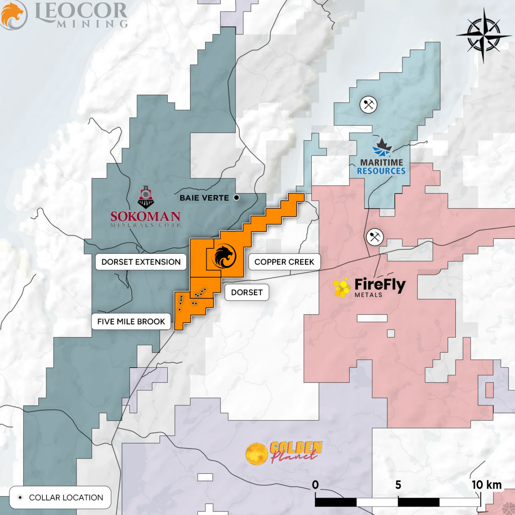
Saga Metals Corp. (“SAGA” or the “Company”) (TSXV: SAGA) (OTCQB: SAGMF) (FSE: 20H) a North American exploration company focused on critical mineral discovery, announces the addition of 180 claims spanning 4,500-hectares, increasing the total size of the Radar Titanium-Vanadium (Ti-V) project from 17,250-hecatres to 21,750-hectares. This addition now encompasses the 20km inferred oxide zone starting from the 2025 Hawkeye drill program area heading west towards the new claim boundary.
Michael Garagan, CGO & Director of SAGA comments: “Important information garnered from the combined field & drill programs suggests the oxide layer zone at Hawkeye may be contiguous to Trapper and possibly as far as SAGA’s claim extension. These additional claims were strategic in an effort to ensure we’ve secured the full extent of mineralization. The team will look to apply magnetic geophysical continuity over the entire ‘inferred layering zone of the Dykes River’ intrusion. The recently completed drill program over the prospective Hawkeye zone is our proof of concept to a much larger system.”
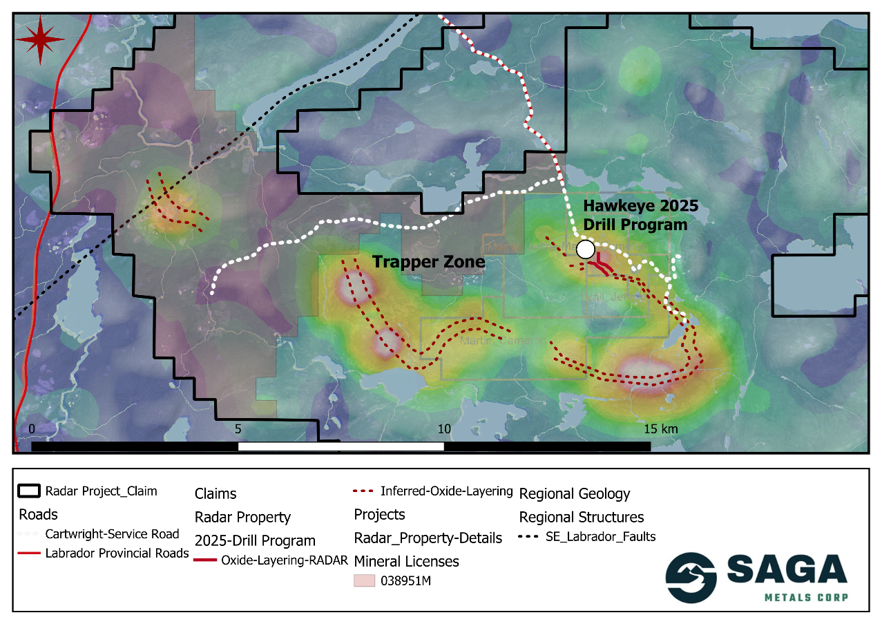
Figure 1: Map of the Radar Ti-V project including recent claim staking and highlights the geophysical anomalies as well as the oxide layer trend
The Radar Ti-V Property is located 10km south of Cartwright in Labrador, Canada. The project now spans 21,750 hectares and benefits from road access and close proximity to a deep-water port supporting efficient exploration and development.
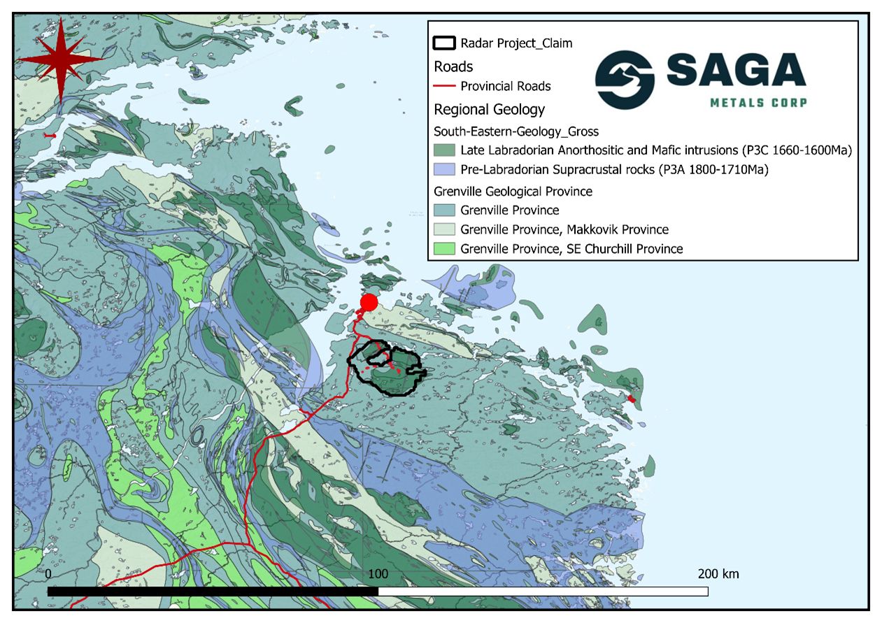
Figure 2: Regional geology of the southeastern Grenville Province and the Radar property
Radar Ti-V Project: Inferred Oxide Zone
SAGA’s in-house geological team had been tracking and defining the oxide layers on the surface based off historical analytical geophysics and two summers of exploration. The team was confident that a limb of the oxide zone extended from the Trapper zone to an unnamed anomaly in the northwest. With the completion of the successful maiden drill program, that showcased drill hole intercepts of the magnetite–oxide layering zone and its potential extent, the team identified the evidence it needed to track the trend into the northwestern section of the property and therefore claimed the final geophysical target in the area.
The inferred layering appears to be continuous from the Hawkeye zone, Trapper zone and the new extension of the property. Whether this is a lopolith feature as defined in the below intrusive model or a fold is yet to be confirmed. Nevertheless, this extensive magnetic anomaly infers the oxide layering trend extends ~20km along strike highlighting the significance of this extension. SAGA has made comparisons with other “textbook” and modeled undeformed layered mafic intrusions such as the Kiglapait intrusion in Northern Labrador.
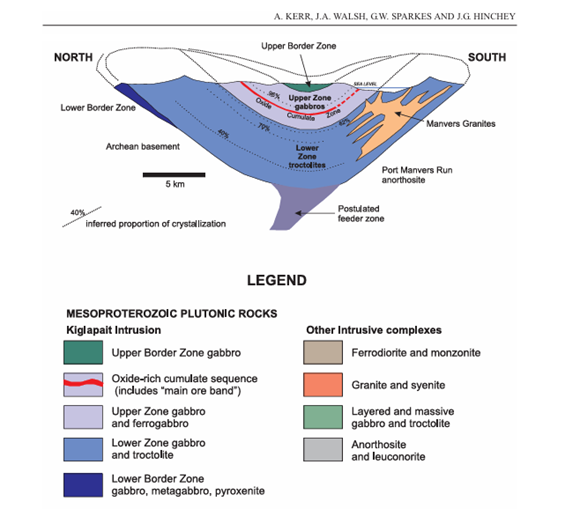
Figure 3: Model of the Kiglapait layered mafic intrusion. Model highlights the stratigraphy of an oxide-rich layering sequence.
A. KERR, J.A. WALSH, G.W. SPARKES AND J.G. HINCHEY. 2013
Q1 2025 Maiden Drill Program:
SAGA’s 2025 maiden drill program aimed to test the core of the magnetic anomaly identified through geophysics at the Hawkeye Zone. Initially planned for 1,500 meters, the program was confidently expanded to 2,200 meters after early drilling revealed strong intercepts through the primary layering sequences.
This program confirmed a large mineralized layered mafic intrusion with early indications suggesting it is moderately undeformed and contains its original primary magmatic textures from over 1 billion years ago. The Dykes River intrusion (Gower 2017), which hosts the entirety of the Radar Ti-V project, has been historically mapped over an area of 160km 2 , which is similar, but larger in size to Greenland’s Skargaard intrusion. This size underscores the immense untapped potential of the region for hosting critical metals, including vanadium and titanium, essential to the global green energy transition.
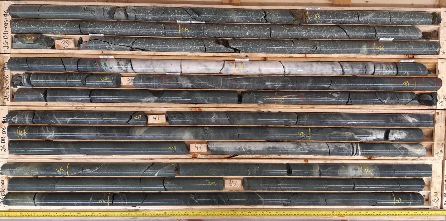
Key findings from drilling include:
- 130–200 meters of intermittent magnetite layering across strike
- Consistent correlation between geophysical anomalies and mineralized zones
- Layered Fe-Ti-V mineralization open at depth
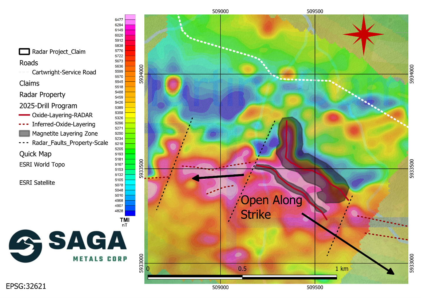
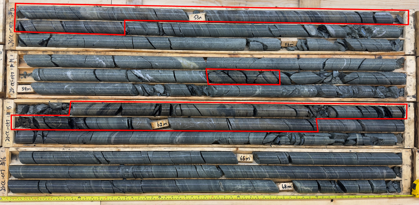
Figure 4: Geophysical map of the Hawkeye zone showing drilled oxide layers and inferred oxide layering open in both directions along strike
SAGA’s exploration team is currently finishing the logging and cutting process with the first shipment of core already sent to the Activation laboratory in Ancaster, Ontario. Due to the quantity of samples, the core will be shipped in three phases. SAGA’s team has prioritized a sequence of drill holes with holes R25-HEZ-01 and R25-HEZ-04 being sent for assaying first. The Company anticipates its initial drill results within the next 4-6 weeks.
R25-HEZ-01 and R25-HEZ-04 were prioritized due to their location on the drill fence which placed them in a position to fully intercept the main oxide layering sequence as seen in the above map. Both of these holes logged magnetite layering sequences between 130-200m across strike.
About Saga Metals Corp.
Saga Metals Corp. is a North American mining company focused on the exploration and discovery of critical minerals that support the global transition to green energy. The company’s flagship asset, the Double Mer Uranium Project, is located in Labrador, Canada, covering 25,600 hectares. This project features uranium radiometrics that highlight an 18-kilometer east-west trend, with a confirmed 14-kilometer section producing samples as high as 4,281ppm U 3 O 8 and spectrometer readings of 22,000cps.
In addition to its uranium focus, SAGA owns the Legacy Lithium Property in Quebec’s Eeyou Istchee James Bay region. This project, developed in partnership with Rio Tinto, has been expanded through the acquisition of the Amirault Lithium Project. Together, these properties cover 65,849 hectares and share significant geological continuity with other major players in the area, including Rio Tinto, Winsome Resources, Azimut Exploration, and Loyal Lithium.
SAGA also holds secondary exploration assets in Labrador, where the company is focused on the discovery of titanium, vanadium, and iron ore. With a portfolio that spans key minerals crucial to the green energy transition, SAGA is strategically positioned to play an essential role in the clean energy future.
For more information, contact:
Saga Metals Corp.
Investor Relations
Tel: +1 (778) 930-1321
Email: info@sagametals.com
www.sagametals.com
The TSX Venture Exchange has not reviewed and does not accept responsibility for the accuracy or adequacy of this release. Neither the TSX Venture Exchange nor its Regulation Service Provider (as that term is defined in the policies of the TSX Venture Exchange) accepts responsibility for the adequacy or accuracy of this release.
Qualified Person
Peter Webster P.Geo. CEO of Mercator Geological Services Limited is an Independent Qualified Person as defined under National Instrument 43-101 and has reviewed and approved the technical information related to the Radar Ti-V Project disclosed in this news release.
Cautionary Disclaimer
This news release contains forward-looking statements within the meaning of applicable securities laws that are not historical facts. Forward-looking statements are often identified by terms such as “will”, “may”, “should”, “anticipates”, “expects”, “believes”, and similar expressions or the negative of these words or other comparable terminology. All statements other than statements of historical fact, included in this release are forward-looking statements that involve risks and uncertainties. In particular, this news release contains forward-looking information pertaining to the Company’s plans and objectives in respect of drill program. There can be no assurance that such statements will prove to be accurate and actual results and future events could differ materially from those anticipated in such statements. Important factors that could cause actual results to differ materially from the Company’s expectations include, but are not limited to, changes in the state of equity and debt markets, fluctuations in commodity prices, delays in obtaining required regulatory or governmental approvals, environmental risks, limitations on insurance coverage, risks and uncertainties involved in the mineral exploration and development industry, and the risks detailed in the Company’s final prospectus in Manitoba and amended and restated final prospectus for British Columbia, Alberta and Ontario dated August 30, 2024, filed under its SEDAR+ profile at www.sedarplus.ca, and in the continuous disclosure filings made by the Company with securities regulations from time to time. The reader is cautioned that assumptions used in the preparation of any forward-looking information may prove to be incorrect. Events or circumstances may cause actual results to differ materially from those predicted, as a result of numerous known and unknown risks, uncertainties, and other factors, many of which are beyond the control of the Company. The reader is cautioned not to place undue reliance on any forward-looking information. Such information, although considered reasonable by management at the time of preparation, may prove to be incorrect and actual results may differ materially from those anticipated. Forward-looking statements contained in this news release are expressly qualified by this cautionary statement. The forward-looking statements contained in this news release are made as of the date of this news release and the Company will update or revise publicly any of the included forward-looking statements only as expressly required by applicable law.
Photos accompanying this announcement are available at:
https://www.globenewswire.com/NewsRoom/AttachmentNg/0949bd0f-0238-445a-a9b2-9dd7681357ea
https://www.globenewswire.com/NewsRoom/AttachmentNg/2cfdb5c0-8a0e-41ce-8a9f-4407b2134649
https://www.globenewswire.com/NewsRoom/AttachmentNg/850e3b0c-3dfb-4d2f-8a2c-e46753ac10f8
https://www.globenewswire.com/NewsRoom/AttachmentNg/bd3acfc8-fe6d-40a1-b1a7-cee33fcc7f84

![]()